


Spain Topo Maps

Description of Spain Topo Maps
Spain Topo Maps is an outdoor navigation application designed for Android devices, providing users with access to topographic maps and aerial imagery of Spain, including the Balearic Islands and Canary Islands. This app is well-suited for outdoor enthusiasts who engage in activities such as hiking, biking, camping, climbing, skiing, and off-road tours. Users can download Spain Topo Maps to navigate through areas without cell coverage, making it an essential tool for backcountry adventures.
The app offers various features that enhance the user experience while exploring the outdoors. One of its primary functions is the ability to download and store map tiles for offline use. By using this feature, users can preload maps for their desired locations, ensuring they have access to necessary navigation tools even in remote areas where cellular service may be unavailable. However, access to offline use requires the purchase of Pro features.
Users can create and edit routes to tailor their outdoor experiences. The route-navigation function allows for point-to-point navigation, facilitating easier movement between waypoints. Spain Topo Maps supports the import of GPX, KML, and KMZ files, enabling users to bring in existing routes and waypoints from other sources. This flexibility is beneficial for those who wish to integrate various mapping data into their navigation process.
The app accommodates an unlimited number of waypoints and tracks, which can be particularly useful for keeping track of multiple locations during a trip. Users can also add custom waypoints using various formats, including longitude/latitude, UTM, or MGRS/USNG, ensuring that they can pinpoint their exact location based on personal preferences or requirements.
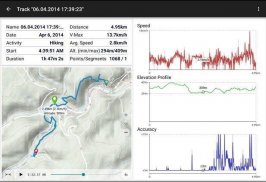
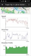
Track recording is another prominent feature of Spain Topo Maps. It provides users with detailed statistics, including speed, elevation, and accuracy profiles. This information can be valuable for users looking to monitor their performance during outdoor activities. The tripmaster function further enhances this capability by displaying critical data fields, such as odometer readings, average speed, distance traveled, and elevation changes.
The app enables users to share their waypoints, tracks, or routes through various platforms, including email, social media, and cloud services like Dropbox. This sharing capability promotes collaboration among outdoor enthusiasts, allowing them to exchange valuable information about their adventures and discoveries. Additionally, users can customize the data fields displayed in the map view and tripmaster, tailoring their navigation experience to suit their preferences.
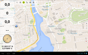
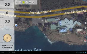
Spain Topo Maps also includes a search function that allows users to find placenames, points of interest (POIs), and streets within the app. This feature streamlines the process of locating specific destinations or landmarks, adding convenience to the navigation experience. The app displays coordinates in multiple formats, including Lat/Lon, UTM, and MGRS/USNG, providing further options for users based on their familiarity with different coordinate systems.
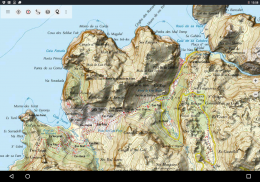
The app includes various map layers to enhance the overall navigation experience. Users can access topographic maps, high-resolution aerial imagery, and several additional map options, such as OpenStreetMaps and ESRI maps. These diverse mapping choices ensure that users have access to the most relevant and useful information for their outdoor activities.
For users interested in optimizing their navigation experience, the app allows them to rotate the map according to their preferences, either "Track Up" or "North Up." This functionality provides users with a more personalized view of their surroundings, enhancing their spatial awareness during outdoor excursions. Elevation data can also be obtained by long-clicking on the map, offering users crucial geographical information about their current location.
Spain Topo Maps is an excellent tool for outdoor navigation, providing a comprehensive suite of features that cater to various user needs. Its offline capabilities, route creation and editing, track recording, and customizable data fields make it a valuable companion for anyone looking to explore the natural landscapes of Spain. The ability to share information and access multiple map layers further enriches the user experience, making this app a reliable choice for outdoor enthusiasts.
With its user-friendly interface and powerful navigation tools, Spain Topo Maps stands out as a preferred option for those seeking to enhance their outdoor adventures. The app’s features are well-designed to support users in navigating remote areas while providing them with the necessary information to ensure a successful trip.
For more information about Spain Topo Maps, you can explore other outdoor navigation applications offered by the developer at: https://play.google.com/store/search?q=atlogis.

Spain Topo Maps - APK Information
APK Version: 7.8.0Package: com.atlogis.spainLatest Version of Spain Topo Maps
Other versions


Apps in the same category


